| Activity |
Site / Description
|
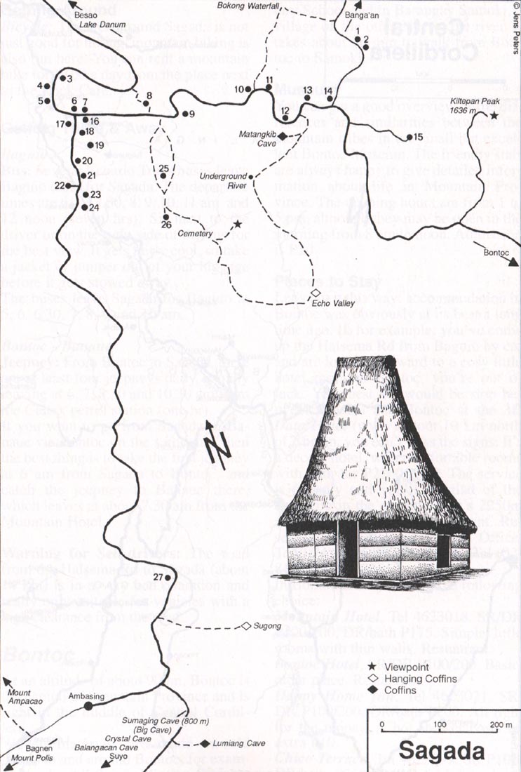
Point in Sagada Map
|
| Museum |
Masferre Gallery
|
14
|
| Shopping |
Arts & Crafts
|
11
|
|
Josephine's Store
|
13
|
|
Sagada Weaving & Souvenir Shop
|
10
|
| Biking |
Balangagang*
A 17 km ride to-fro Sagada, Passing
through Suyo road to Balangagang (4 km), then back to Sagada via
Baguio/Bontoc road south of Dantay (4 km), and finally from Dantay
back to Sagada (9 km).
|
| Sumadel /Tadian*
A 40km circuit along steep and rugged
road passing through mountain sceneries and traditional villages.
Sagada - Basao - Sumadel - Tadian - Abatan, Bauko - Sabangan - Dantay
- Sagada.
|
| Sagada/Bessang
Pass*
A 140 km run from Cordillera to Ilocos,
wading across Abra river and passing through steep and slippery
Bessang Pass. Sagada - Besao - Sumadel - Tadia (road to Cervantes)
- Abra River - Bessang Pass - Tagudin - San Fernando - Vigan.
|
|
Hiking / Trekking
|
Banga`an (Bomod-ok Waterfall)
Two hours north east of Sagada.
After reaching a school in Banga`an, turn right to Fedilisan Village.
Inhabitants can take you to the waterfall for a few pesos.
|
|
Bokong Waterfall
Thirty minute walk from Sagada. After
Sagada Weaving, turn left up the stairs.
|
|
Echo Valley
Go through the cemetery, take path
down into the valley. Coffins can be seen from the valley. You can
also go upriver where the Underground River flows out and continue
right on to Matangkib Cave.
|
|
Kiltepan Peak
At 1636m high, 1.5km east of Sagada,
you can see Kilong and Tetep-an Rice Terraces.
|
|
Mt. Ampacao
A 2 hr hike from Sagada, at 1889m
high, it offers the view of Sagada and its surrounding area.
|
|
Mt. Polis
A 4 hr hike south of Sagada, at 1829m
high, along the Old Spanish Trail leading to Bagnen.
|
|
Mt. Sipitan
A one-day hike to the highest point
in Sagada, at 2200m high. Offers view from the southern edge of
the Mt. Province-Kalinga-Abra border. Guides can be hired in Sagada
for P600 - P1000.
|
|
Northern Bontoc*
A few day hike leading through
northen Bontoc villages. Dalican and Malegcong Village offers spectacular
view of the rice terraces while Mainit showcases gold mines and
hot springs. From Sagada, you can reach Dalican either through Baang
(shortest but difficult), Tanulong, Banga`an or Aguid (longest but
easiest). Then from Dalican, it's a 3 hr hike to Mainit. From there
you can either go to Maligcong(2 hrs), Bontoc (3 hrs) or Sadanga
(3 hrs).
|
|
Sagada - Abra*
This long expedition starts from
Banga`an, from there the trail leads 10km (8 hrs) to Be-ew crossing
a river. Stay the night in Be-ew or Tagpew Falls and continue on
to Quili (4 hrs). Either stay overnight or go further on to Tubo
for another 4 hrs. From there, take a jeep to Manabo, Abra. You
can either stop in Manabo or carry on to Bangued and out to the
coast near Vigan. Guides can be found in Lacmaan, Agawa or Gueday,
all in the town of Besao.
|
|
Tagpew Falls*
Refer to Sagada - Abra expedition
for directions. Gueday is the closest place to the falls. From there,
walk up a stream and up a very steep ridge for 2 hrs. Follow the
trail leading north/north east towards Abra. 4 hrs of walking along
ridgetops, descend into a heavily-forrested valley. After an hour,
turn left down the stream, walk for 250m and emerge at the top of
the falls. There's a campsite in the vicinity. You can explore the
bottom of falls by going down a narrow, slippery and steep trails
(150-200m).
|
|
Tirad Pass*
This is a historic site where Gregorio
del Pilar died in the battle against the Americans. A 2-3 day trek
starting from Sagada, to Besao and to Tamboan (2.5 hrs from Besao).
From Tamboan going up to Pang-wew, then 3 hrs hike to Bab-asig.
Descending from Bab-asig to Abra river for 3 hrs, wade across the
river and walk for another 45 mins to Legleg. From Legleg, continue
on to San Emilio, Ilocos Sur. The path to Tirad Pass is 4km out
of town branching off to the left. You can press on to Gregorio
del Pilar (5-6 hrs), then to Salcedo (3 hrs), and down to Buwaya
River. Guides can be found from various stopovers.
|
|
Spelunking
|
Balangagang*
The cave entrance is a 3 hr hike
south of Sagada. It is the lowest part of Sagada's cave system and
also the lowest part of the cave. You'll do a lot of climbing instead
of descending.
|
|
Crystal*
Located 2 hrs south of town, this
cave is well-known for its calcite crystal imbedded staclactites
and stalagmites. The entrance is obscured so you'll definitely need
a guide. Full exploration of the cave requires an entire day. Unfortunately,
it was closed off 2 years ago due to looting.
|
|
Matangkib*
A 200m long cave. You can reach the
entrance by taking the trail across Rock Valley Inn. The path leading
away from the stream at the upstream end can take you to a waterfall
in Bokong.
|
|
Known as "The Big Cave", 800m south of Sagada.
The first hundred meters descent is quite slippery and steep. The
cave house an impressive array of rock formations and several chambers,
one of them holds a pool. The whole cave takes at least 6 hrs to explore
and requires technical equipments and caving skills. The usual route
for tourists takes at least 3 hours to complete. |
|
For complete info, see Jens Peters' Philippines
Travel Guide @ www.travelphil.com
& *Robert
Houston's Action
Asia Adventure Travel Guide to the Philippines
Back
to Top
|
 Agriculture
is the main source of income in Sagada. Cabbages, carrots, and potatoes
arecommon crops while rice is planted for household consumption. Sagada
also earns significantly from its tourism industry. It is known for its
pleasant climate, pine sceneries, rocky terrain, waterfalls, centuries-old
burial caves, underground rivers, rice terraces, local weaving and hanging
coffins.
